- From the Bank
- Posts
- Why dark water on Google Earth means bigger bass
Why dark water on Google Earth means bigger bass
(avoid the light brown ponds that waste your time)
Hey, it's Keith.
You've probably used Google Earth to find ponds and lakes in your area, but you can spot dozens of potential fishing spots without knowing which ones are actually worth your time.
The problem is that all ponds look basically the same in satellite imagery unless you know what to look for.
Ten years ago I had to choose between two similar-looking ponds using Google Earth. The technique I discovered that day helped me consistently find established waters loaded with bass and changed how I scout forever.
Today, I'm sharing the Google Earth method that helps me identify clean, established ponds while avoiding muddy time-wasters.
BEST LINKS
What I looked at this week
How to use Google Earth the find fish (Eagle Claw)
Find fishing spots with Google Earth (Rip Lips Tips)
Change your fishing forever with this Google Earth trick (Fish the Moment)
Find the best fishing ponds – Google Earth tricks (Chris Bulaw)
Escape fishing pressure with these Google Earth tips (Fish the Moment)
Deals of the week
Bass Pro Shops has Lew’s Custom SLP Baitcast Reel marked down from $179.95 to $119.95.
Amazon has Dobyn’s Maverick Series Rods marked down from $99.99 to $52.93!
Bass Pro Shops marked down Korkers BuckSkin/Kling-on Wading Boots from $159.99 to $119.97.
DEEP DIVE
The Google Earth history trick that finds trophy-bass waters
About 10 years ago, I was planning my next fishing trip using Google Earth and had narrowed it down to two ponds. After spending two hours examining possibilities, I had to make a choice.
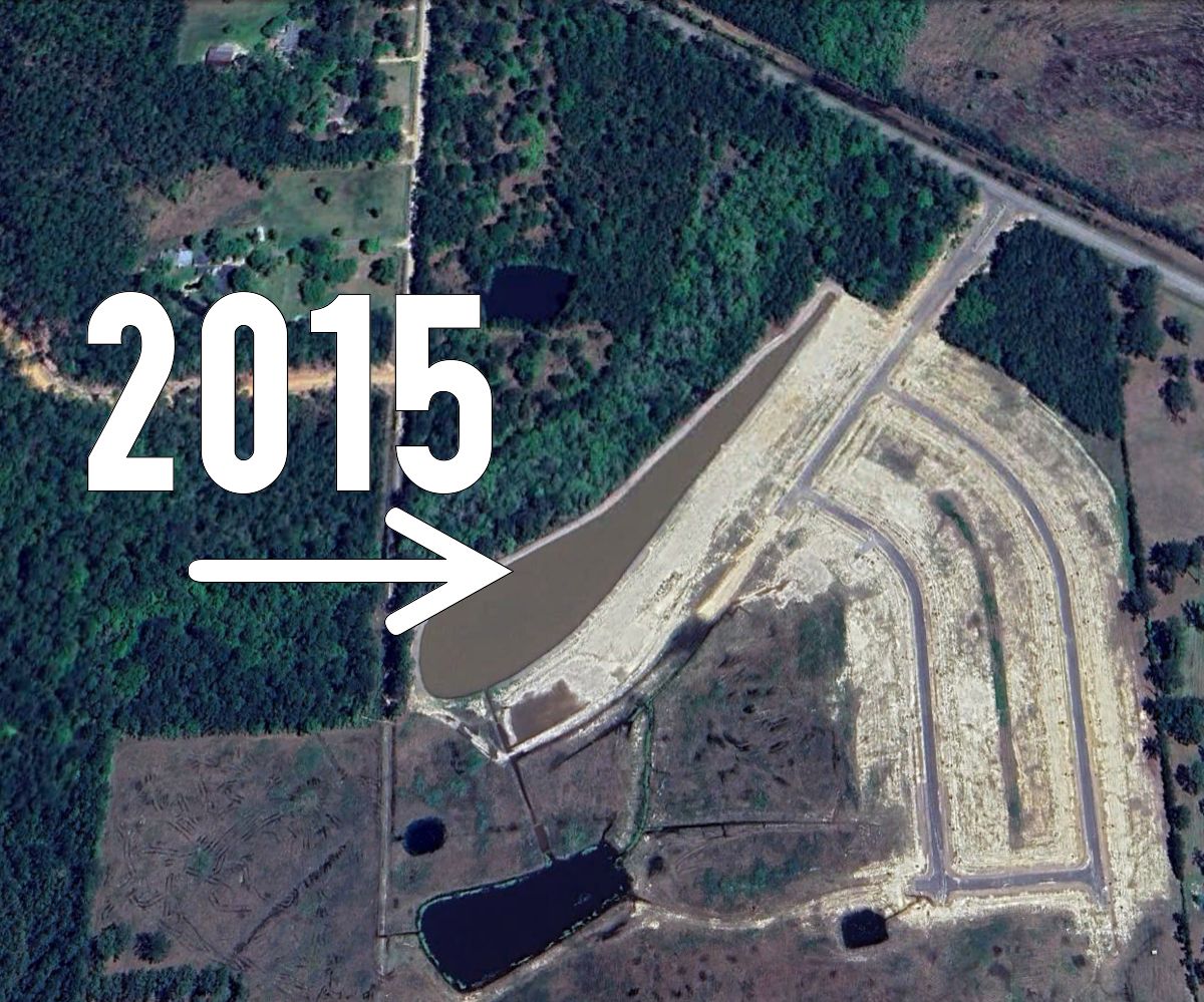
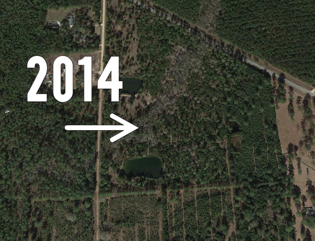
The first was a two-acre pond built along the backside of a neighborhood that looked perfect in the satellite view. The second was tucked back in the woods off the interstate, harder to access but promising.

This pond looked like a great spot to fish back when I first spotted it in 2015.
As I examined both ponds closely, I noticed something odd about the neighborhood pond: the water had a light brown color that seemed off. That's when I discovered Google Earth's history feature.
I clicked the history button and went back one year. The neighborhood pond wasn't even there. That light brown water was a dead giveaway; it was newly dug, which explained the muddy conditions.
I then checked the interstate pond's history. One year back, same clear color. Five years back, identical. Ten years back, still there.

I went back a year and this is what I found.
My decision was easy. I drove out early, walked about a mile down the service road to reach the hidden pond, and found exactly what I expected: beautiful, established water loaded with grass and lilies.
That day I brought home a limit of 10 bass, the biggest a three-pounder that crushed my ChatterBait in the thick vegetation.
My complete Google Earth scouting system
Step 1: Identify pond age using history
The history feature is your most powerful tool. Click the clock icon and scroll back through years of satellite imagery. Here's what you need to look for:
When the pond first appears (newer than five years means caution)
Consistent water color over time (indicates stability)
Vegetation development around edges
Any major changes or construction nearby
Step 2: Read the water color
Established ponds have distinct characteristics in satellite imagery:
Clear to dark-green water indicates a healthy ecosystem.
Light brown or tan water often means recent construction.
Ponds with varied color zones show natural depth changes.
Bright blue can indicate chemical treatment or artificial conditions.
Step 3: Look for ecosystem development
Mature ponds show clear signs of natural succession:
Vegetation growing along shorelines
Lily pads and grass beds visible in shallows
Trees and brush established around perimeter
Natural-looking irregular shorelines versus geometric shapes
Step 4: Spot the hidden gems
Don't write off muddy-looking ponds immediately. Use the history feature to check if they're more than five years old. Then zoom in and examine for details:
Dark sections along edges (clean water pockets)
Culverts or creeks feeding clean water
Areas where grass and vegetation filter the water
These mixed-condition ponds can be gold mines.
Why pond age matters for bass fishing
Here in Louisiana, bass mature to double-digit size in 6–10 years. A pond built 8 years ago is likely at its peak productivity. Here's what happens as ponds mature:
Years 1–2 (migration stage): New water attracts insects, birds bring seeds and eggs, basic organisms establish. Water is often muddy from construction.
Years 3–5 (colonization stage): Submerged plants like pondweeds and starwort take root, waterlilies establish, water begins clearing as vegetation filters sediment.
Years 6+ (establishment stage): Dense vegetation coverage, stable ecosystem, mature fish populations, optimal bass habitat with cover and forage.
So, how does this connect to bass fishing?
Older ponds have settled water that allows vegetation to flourish. This vegetation creates the perfect habitat: cover for bass, oxygen production, and abundant forage like bluegill that feed on the plant life.
Pro tips for Google Earth scouting
Check multiple seasons if available (spring imagery shows vegetation better).
Look for access points like service roads or trails.
Note nearby development that might affect water quality.
Save promising locations with pins for future reference.
Cross-reference with topographic maps to understand depth potential.